
“The 4D Virtual Museum of the City of Bologna, Italy” by Bocchi, Bonfigli, Ghizzoni, Smurra and Lugli
Conference:
Experience Type(s):
Title:
- The 4D Virtual Museum of the City of Bologna, Italy
Program Title:
- Electronic Schoolhouse (Classroom)
Organizer(s)/Presenter(s):
Description:
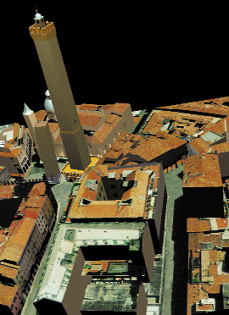
Bologna is a major Italian city. It is the largest town and the administrative center of the Emilia-Romagna region, and is located more or less midway between Florence and Venice, in the Po Valley, to the north of the Apennines, the mountain chain that separates the northern part of Italy from the peninsular part, at the northern end of several valleys linking Emilia-Romagna and Tuscany. Today, Bologna has a population of about 400,000, and it has a long historical and cultural tradition. It is known the world over for having the oldest university in Europe (dating back to about 1088) and for its characteristic architectural and urban structure. In the city center, nearly all the streets are built with arcades, known as portici, a continuous series of arches along both sides of the street forming an integral part of the urban structure. Even today, there are more than 25 miles of these arcades in the city center.
It is extremely difficult to construct a museum illustrating the history of the city inside a building, above all when there is a need to show the dynamic phases of history. New developments, periods of decline, new settlements, and changing buildings are all elements that are difficult to present to the public in a satisfactory manner. The New Electronic Museum is using computer graphic techniques to reconstruct the transformations of Bologna, so that the public can see the changes that took place, and to present the results of historical research with a high level of accuracy in terms of cartographic and architectural reconstruction.
Information technology and the information superhighway enable us to move on to a new frontier of research into urban history, making it possible to carry out a three-dimensional electronic reconstruction of the urban habitat and its historical transformations. The result will be a four-dimensional city, with the three spatial dimensions plus the temporal one.
This project combines historical research and new technology to produce results that traditional research methods could never achieve. It is therefore necessary to introduce new approaches to our work, both with regard to the methods used in historical research, and to the transfer of that research to a virtual reality environment. It must be stressed that the method illustrated is not valid solely for the city of Bologna, but rather the city of Bologna is the place where experimentation with this method is taking place. The same method is valid for all cities, whether they be ancient or modern, European, African, Asian, or American.
The Fundamental Role of Historical Research in the Implementation Phase
The first phase consists of historical research based on analysis of documents and identification of the cartographic sources and other useful pictorial sources. This phase is particularly complex with regard to the period (ancient and Medieval) for which no pictorial sources have been handed down to us. Precise visual representations of the buildings and urban structure no longer exist.The only available sources of information for those early periods are the records of the notaries public, government acts, property lists, and tax records.
Even the oldest pictorial records (from the Renaissance onwards) are not always easy to transpose into geometric and virtual forms. Once again, these records must be studied in depth before they can be used. It is necessary to work out why they were produced and what they were intended to illustrate in order to understand the contents and interpret them.
Autocad Modeling
Once the analysis of the historical sources (documentary, narrative, pictorial) has produced satisfactory results, the next step is the modeling phase, implemented by experts in the construction industry (engineers and architects) who have to formulate geometrical models based on the data taken from the documentary sources and combine models and materials used in the various historical periods with the building and urban components that were in existence at that time.
This is a critical phase in the reconstruction work and is preceded by a complex data-processing operation. We intend the model under construction to have a scientific rigor that distinguishes the New Electronic Museum from other products currently available on the market. In order to achieve this level of reliability, it is necessary to start from an accurate two-dimensional map, identifying the precise geographical location (latitude, longitude, altitude) of the buildings.
Four-Dimensional Navigation: the 4D Interface System
The results of the research and the modeling are entered into a virtual environment
governing the “time machine.”
The Use of Written Sources for Reconstruction of the City in Virtual Reality
When we reconstruct the city in a virtual reality environment, we are not only showing something that is no longer accessible. We are also examining the past by analyzing each part, showing how each element is linked to the others. The sources available to us provide a great deal of information relating directly to physical structures, such as streets, buildings and land, but they also provide much indirect information about various aspects of life in the city.
The records known as the Libri terminorum are, without a doubt, the documents that provide the most significant information about the urban structure in spatial terms. They were drawn up by teams of land surveyors and by officials appointed by the city
administration on a number of occasions (1245, 1286, 1294) to lay down a series of ground markers or termini to mark off public areas in the squares, in the streets, and along the city walls from private property. They were laid down in positions that were
easily recognizable, such as the corners of buildings and arcades or portici. The Libri terminorum not only provide a list of these ground markers but also a great deal of other information about the buildings. The surveys took into account the upper floors
of the buildings, with overhanging beams and guttering: if there were any overhanging features, questions were asked about whether they were built over private ground.
For the purposes of our research project, the careful attention to detail of the land surveyors is of great importance.The precise measurements between one ground marker and the next enables us to see the exact relation between the various elements taken as reference points for the identification of the ground markers. These documents also enable us to locate many buildings on the city map: this degree of resolution is made possible by the care with which the various householders were listed together with their property.
The database designed to manage this documentation needs to show the buildings as the result of social, historical, and property relations over a long period of time. Most of the information in the database concerns people, structures, and places, but the contents are not simply a list of such items. We need to bring together the various components that contribute to urban development so that each person is linked to the others who are in some way related. In the same way, the buildings need to be linked up with their owners and inhabitants.The mass of data put together in this way produces the information that is the basis for the production of hypertexts and for modeling the structures that are recreated in the virtual reality environment of the New Electronic Museum.
The Map of Bologna in Perspective (1575)
For the Holy Year of 1575, Pope Gregory XIII ordered a room in his private apartments in the Vatican to be decorated with a large pictorial map (seven meters across and five meters high, scale 1:360) of Bologna, the city of his birth. It appears that this fresco served a strategic purpose for control and management of the city and the surrounding area. To be able to cast an eye over a pictorial map of the city was a way of possessing it, in material and not just symbolic terms.
This fine pictorial map of Bologna, in which topographic detail is enhanced by landscape painting, consists of a bird’s-eye-view perspective in which the hypothetical viewpoint is located high up in the sky over the northeastern sector of the city. Until recently, this map has been used to support various hypotheses about the urban development of Bologna, but now software applications enable us to move on to a qualitatively different kind of analysis of the sources.
The fresco in the Vatican is being used as the main source to produce a three- dimensional model of Bologna in the second half of the sixteenth century. To this end, there is a need to ascertain the reliability of the fresco, using scientific criteria, in order to be sure that this was a pictorial account of the city as it really was and not just a fresco based on the painter’s imagination. Because of the complex changes that have taken place in the urban layout, such an analysis cannot be based simply on a comparison between the elements reproduced in the pictorial map (streets, buildings, squares) and the surviving structures. It is necessary to carry out a careful analysis of the map.
An initial analysis shows that the map has a high degree of reliability: there is a close match between the street frontages of the buildings and the measurements of the building plots in the land registry records (1833).These comparisons lead us to believe that the Vatican artist worked from a plan made in the same period that has unfortunately not been handed down to us, showing the development of the city center on paper.
Historians are able to use the fresco of Bologna as a reliable historical source, free from inventive work and flights of imagination by the artist. It is important to underline that, for the purposes of our project, the map in the Vatican is of great interest for the reconstruction of sectors and individual buildings that have undergone major refurbishment or reconstruction.
Moreover, thanks to the map’s scale, it is possible to carry out a close reading of the buildings, including features of individual buildings, both civil and religious.
From Historical Sources to CAD Modeling
The city itself is a complex form. It is not an entity that perfectly conforms to elementary and standard geometric forms. It is characterized by irregular, geometric forms found in its external confines and in its complex division of streets and housing lots. In these situations, there does not exist a street that is perfectly rectilinear or a tower that is exactly vertical. Also, the dimensions and forms of habitation spaces are not perfectly subjugated in one, simple reticular form. This diversity of form provides information about the genesis of the city itself, offering hints as to how the city appeared in other times and how it expanded.
The precision of topographic operations when dealing with the necessity of reducing scale, can only be solved today with digital cartography based on CAD generating systems, which allows the possibility of overcoming the scale problem in graphic representation. The computer does not memorize the graphic nor the mathematical characteristics. Instead, it allows each mathematical element to be associated with information concerning the characteristics of the objects themselves.
In this way, the computer initiates the algorithm of representation, or in other words, “produces” the image instead of merely reproducing it, which allows the output of the machine to regenerate every time from zero.
The 4D Interface System
The interface of the prototype version of Nu.M.E., the New Electronic Museum, is designed and implemented in order:
• to provide different types of users with simple and efficient navigation tools to look back over the historical and urban development of the city from the end of the first millennium to the present day.
• to show visitors the fundamental role that historic research plays in the project.
The New Electronic Museum Interface consists of a VRML browser for the 3D display and specific 4D navigation tools in order to improve management of both spatial navigation and temporal navigation.
The spatial navigation orientation tools consist of:
• A 2D orientation map of the area of Bologna reproduced in the New Electronic Museum that allows visitors to visualize their position in the virtual world with a red rectangle and the direction for viewing the city with a green rectangle. The map can be shown or hidden by means of a button on the console.
• A virtual terrain model that allows the user to visualize each virtual building considering the altitude parameter in order to measure distances and areas and to carry out simulations related to the relief of the terrain.
The temporal navigation orientation tools consist of:
• A time-bar that includes a text field showing the year on display and a bar with a cursor showing the time line. By selecting a year, it is possible to visit the entire reconstructed city.
• The sound environment by which each century is associated with a different sound- track, that allows visitors to identify, at an intuitive and perceptive level, the period in which they are visiting the city.
Finally, the New Electronic Museum interface needs to make clear some concepts related to the historic research:
• The need to reverse the chronological order of the research itself. The visitor begins to tour the city in the present and then travels backward in time, watching existing buildings disappear into the ground or change appearance, after which the buildings that no longer exist then pop up.
• The principle that the New Electronic Museum shows only as much as the historical sources will justify. Each building is therefore accompanied by a hypertext link with a description and references to the historic sources on which the virtual reconstruction is based.
Panelists:
Maria Elena Bonfigli
Manuela Ghizzoni
Rosa Smurra
University of Bologna
Other:
Fernando Lugli
Centro Ricerche S.C.R.L.