
“Automatic generation of tourist maps” by Grabler, Agrawala, Sumner and Pauly
Conference:
Type(s):
Title:
- Automatic generation of tourist maps
Presenter(s)/Author(s):
Abstract:
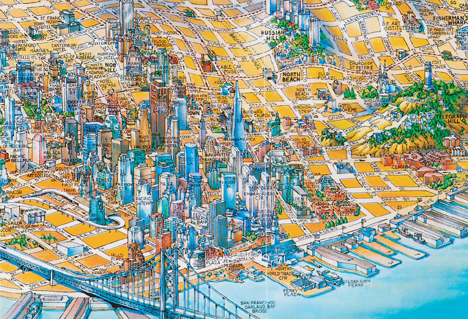
Tourist maps are essential resources for visitors to an unfamiliar city because they visually highlight landmarks and other points of interest. Yet, hand-designed maps are static representations that cannot adapt to the needs and tastes of the individual tourist. In this paper we present an automated system for designing tourist maps that selects and highlights the information that is most important to tourists. Our system determines the salience of map elements using bottom-up vision-based image analysis and top-down web-based information extraction techniques. It then generates a map that emphasizes the most important elements, using a combination of multiperspective rendering to increase visibility of streets and landmarks, and cartographic generalization techniques such as simplification, deformation, and displacement to emphasize landmarks and de-emphasize less important buildings. We show a number of automatically generated tourist maps of San Francisco and compare them to existing automated and manual approaches.
References:
1. Agrawala, M., and Stolte, C. August 2001. Rendering effective route maps: Improving usability through generalization. In Proc. SIGGRAPH, 241–249. Google ScholarDigital Library
2. Agrawala, M., Zorin, D., and Munzner, T. June 2000. Artistic multiprojection rendering. Eurographics Rendering Workshop, 125–136. Google ScholarDigital Library
3. Ali, K., Hartmann, K., and Strothotte, T. 2005. Label Layout for Interactive 3D Illustrations. Journal of WSCG 13, 1, 1–8.Google Scholar
4. Appleyard, D. 1969. Why buildings are known: A predictive tool for architects and planners. Environment and Behavior 1, 2, 131.Google ScholarCross Ref
5. Bader, M. 2001. Energy Minimization Methods for Feature Displacement in Map Generalization. PhD thesis, Univ. of Zurich.Google Scholar
6. Deakin, A. 1996. Landmarks as navigational aids on street maps. In Proc. CAGIS 23, 1, 21–36.Google Scholar
7. Denis, M., Pazzaglia, F., Cornoldi, C., and Bertolo, L. 1999. Spatial discourse and navigation: an analysis of route directions in the city of venice. Applied Cognitive Psychology 13, 2, 145–174.Google ScholarCross Ref
8. DiBiase, D., MacEachren, A., Krygier, J., and Reeves, C. 1992. Animation and the role of map design in scientific visualization. In Proc. CAGIS 19, 4, 201–214.Google Scholar
9. Edmondson, S., Christensen, J., Marks, J., and Shieber, S. 1996. A General Cartographic Labelling Algorithm. Cartographica: The Int. Journal for Geographic Information and Geovisualization 33, 4, 13–24.Google ScholarCross Ref
10. Felzenszwalb, P., and Huttenlocher, D. 2004. Efficient graph-based image segmentation. IJCV 59, 2, 167–181. Google ScholarDigital Library
11. Forberg, A. 2007. Generalization of 3d building data based on a scale-space approach. In Proc. ISPRS 62, 2, 104–111.Google Scholar
12. Hartmann, K., Götzelmann, T., Ali, K., and Strothotte, T. 2005. Metrics for Functional and Aesthetic Label Layouts. Int. Symp. on Smart Graphics 5, 115–126. Google ScholarDigital Library
13. Hays, J., and Efros, A. 2007. Scene completion using millions of photographs. ACM Trans. Graph. (Proc. SIGGRAPH) 26, 3, 4:1–4:8. Google ScholarDigital Library
14. Holmes, N. 1991. Pictorial Maps. Watson-Guptill.Google Scholar
15. Imhof, E. 1975. Positioning names on maps. The American Cartographer 2, 2, 128–144.Google ScholarCross Ref
16. Jiang, B., and Claramunt, C. 2004. A structural approach to the model generalization of an urban street network. GeoInformatica 8, 2, 157–171. Google ScholarDigital Library
17. Kada, M. 2002. Automatic generalisation of 3D building models. In Geospatial Theory, Processing and Applications 34, 4.Google Scholar
18. Klippel, A., and Winter, S. 2005. Structural Salience of Landmarks for Route Directions. In Proc. COSIT 2005, 347–362. Google ScholarDigital Library
19. Kraak, M., and Ormeling, F. 1996. Cartography. Visualization of spatial data. Harlow: Longman.Google Scholar
20. Lovelace, K., Hegarty, M., and Montello, D. 1999. Elements of good route directions in familiar and unfamiliar environments. In Proc. COSIT ’99, 65–82. Google ScholarDigital Library
21. Lynch, K. 1960. The Image of the City. MIT Press.Google Scholar
22. MacEachren, A. 1995. How Maps Work: Representation, Visualization, and Design. Guilford Pubn.Google Scholar
23. Mackaness, W., and Beard, K. 1993. Use of graph theory to support map generalization. In Proc. CAGIS 20, 4, 210–221.Google Scholar
24. McMaster, R., and Shea, K. 1992. Generalization in digital cartography. Association of American Geographers.Google Scholar
25. Michon, P., and Denis, M. 2001. When and why are visual landmarks used in giving directions? In Proc. COSIT ’01 2205, 292–305. Google ScholarDigital Library
26. Mirtich, B. 2005. Fast and Accurate Computation of Polyhedral Mass Properties. Graphics Tools: The JGT Editors’ Choice. Google ScholarDigital Library
27. Monmonier, M. 1993. Mapping It Out: Expository Cartography for the Humanities and Social Sciences. Univ. of Chicago Press.Google Scholar
28. Nothegger, C., Winter, S., and Raubal, M. 2004. Computation of the salience of features. Spatial Cognition and Computation 4, 2, 113–136.Google ScholarCross Ref
29. Raubal, M., and Winter, S. 2002. Enriching Wayfinding Instructions with Local Landmarks. GIScience: Second International Conference 2478, 243–259. Google ScholarDigital Library
30. Sester, M. 2000. Generalization based on least squares adjustment. In Proc. ISPRS 33, 931–938.Google Scholar
31. Snavely, N., Seitz, S., and Szeliski, R. 2006. Photo tourism: exploring photo collections in 3d. ACM Trans. Graph. (Proc. SIGGRAPH) 25, 3, 835–846. Google ScholarDigital Library
32. Sorrows, M., and Hirtle, S. 1999. The nature of landmarks for real and electronic spaces. In Proc. COSIT ’99, 37–50. Google ScholarDigital Library
33. Southworth, M., and Southworth, S. 1982. Maps: A Visual Survey and Design Guide. Little Brown and Company.Google Scholar
34. Staufenbiel, W. 1973. Zur Automation der Generalisierung topographischer Karten mit besonderer Berücksichtigung grossmasstäbiger Gebäudedarstellungen. PhD thesis, Univ. of Hanover.Google Scholar
35. Tezuka, T., and Tanaka, K. 2005. Landmark extraction: a web mining approach. spatial information theory. Lecture Notes in Computer Science 3693, 379–396. Google ScholarDigital Library
36. Thiemann, F. 2002. Generalization of 3D building data. In Geospatial Theory, Processing and Applications 34, Part 4.Google Scholar
37. Thomson, R., and Richardson, D. 1995. A graph theory approach to road network generalisation. In Proc. ICC 17, 3–9.Google Scholar
38. Thomson, R., and Richardson, D. 1999. The ?good continuation?principle of perceptual organization applied to the generalization of road networks. In Proc. ICC 19, 1215–1223.Google Scholar
39. Tufte, E. 1990. Envisioning Information. Graphics Press. Google ScholarDigital Library
40. van Kreveld, M. 2001. Smooth generalization for continuous zooming. In Proc. ICC 20, 2180–2185.Google Scholar
41. Vollick, I., Vogel, D., Agrawala, M., and Hertzmann, A. 2007. Specifying label layout style by example. In Proc. UIST, 221–230. Google ScholarDigital Library
42. Ware, J., and Jones, C. 1998. Conflict reduction in map generalization using iterative improvement. GeoInformatica 2, 4, 383–407. Google ScholarDigital Library
43. Weibel, R., and Jones, C. 1998. Computational Perspectives on Map Generalization. GeoInformatica 2, 4, 307–314. Google ScholarDigital Library
44. Zipf, A. 2002. User-Adaptive Maps for Location-Based Services (LBS) for Tourism. Information and Communication Technologies in Tourism, 329–338.Google Scholar