
“The Creation of the Nu.M.E. Project” by Guidazzoli and Bonfigli
Conference:
- SIGGRAPH 1999
-
More from SIGGRAPH 1999:


Type(s):
Title:
- The Creation of the Nu.M.E. Project
Program Title:
- Electronic Schoolhouse (Playground, Workshop)
Organizer(s)/Presenter(s):
Description:
The methodology of the Nu.M.E project, as presented in the Classroom Panel “The 4D Virtual Museum of the City of Bologna”, is based on the virtual reconstruction of Medieval and Renaissance buildings and streets. This workshop presents the 4D navigation and graphic processing phase of the project.
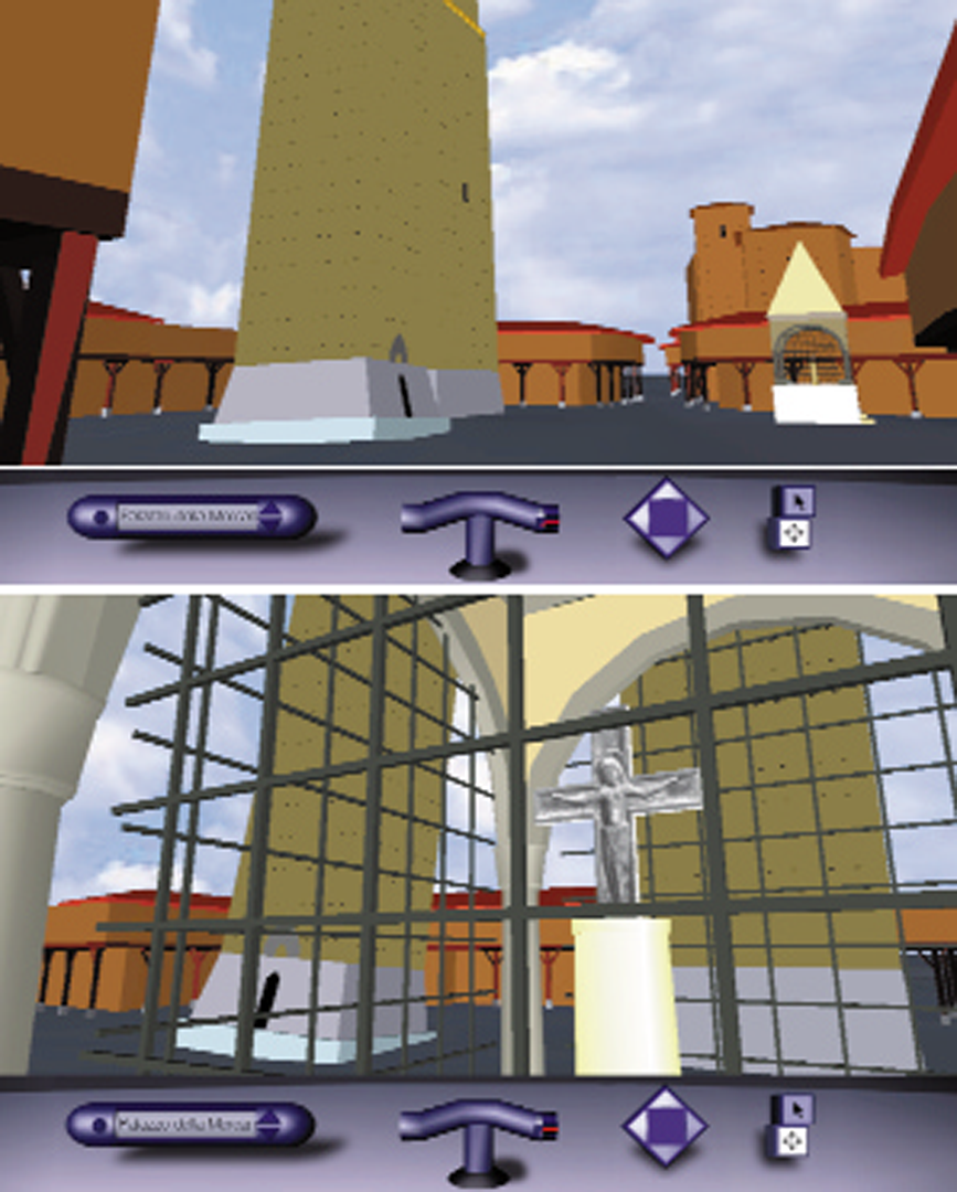
In the new millennium, the world will be increasingly connected by high-bandwidth links that will allow the virtual visitor, seated in front of a monitor anywhere, to take the New Electronic Museum’s electronic tour of the Medieval streets of Bologna. Visitors will be able to look up at the Garisenda tower, as Dante did, and be impressed by the gathering clouds above, go up to the top of the Asinelli tower, admire Piazza Maggiore as it appears today or as it appeared in the 13th century, see the urban settlement where the oldest university in the world was founded, and walk under the portici today or in the past. They will be able to choose any street or period, in the hope of being able, sooner or later, to see this extraordinary city in real life.
Implementation Phases and the Time Machine
The results of the research and the modeling work were entered into a virtual environment governing the “time machine.” Modeling techniques made it possible to reconstruct buildings that are no longer in existence. The navigation system enabled views of historic elements that are no longer in existence and removal of items that were not yet in existence during a given period.
A “time machine” in the program’s tool bar allows visitors to select a historical period for an electronic walk through the city of the past. Visitors can access views of Piazza di Porta Ravegnana with the Asinelli and Garisenda towers and the surrounding streets, the Chapel of the Cross (fourth-18th centuries), three medieval towers that were demolished at the beginning of the 20th century, Piazza Maggiore, and the interior of the basilica of S. Petronio.
Coordination of the Working Environment
At this stage of the project’s development, various groups are working in parallel, coordinated by means of a “shared environment” that enables them to exchange information among themselves. The Nu.M.E. Cooperative Open Environment is used to gather the data from the various laboratories and download it for processing.
The work presented in this workshop is only the tip of the iceberg of a great scientific enterprise with sophisticated software applications that the “visitor” cannot see, but which are the basis of the final product. Every mark, drawing, and movement is
derived from in-depth historical research, since it is the quality of the historical research, over and above the software applications, that makes the difference between a multimedia product of a purely commercial kind, of which there are many on the market, and the New Electronic Museum project.
Four-Dimensional Navigation as a Summary of Historical Research.
In order to provide the visitor with the scientific information on which the product is based, every building, every urban sector, and every single item is accompanied by the sources on which the vector model is constructed and which make the three-dimensional navigation possible. These sources may be called up on the screen at any time during the electronic tour. One advantage of this electronic museum is that it is accessible at all levels of competence and knowledge, and visitors can make their own personal interpretation of the materials.
The project is both an instrument of scientific research and a new means of disseminating scientific knowledge (in this case, about urban history and cultural and conservation studies), and, at the same time, a means of stimulating interest in applications of technology that are likely to see further development.
Implementing the Nu.M.E. Project
The idea of making the Nu.M.E. or New Electronic Museum project accessible on the Internet (www.cineca.it/visit/nume/) arises from the need to facilitate interaction with historical researchers, to reach a greater number of users, and, of course, to publicize the project. For this reason, we chose to implement Nu.M.E. with VRML and Java that also make it possible to develop dynamic and interactive 3D environments in a portable, standardized, and platform-independent manner.
Briefly, the implementation process of the Nu.M.E. project consists of progressive introduction of 3D models of buildings in the virtual 4D city model. This process can be subdivided into four phases. During the translation phase, the CAD model of a
building must be translated into VRML2 format, which requires modifying some characteristics of CAD solid modeling:
• To maintain only the surface information to be used in the VRML representation.
• To introduce a hierarchy among the different components that constitute a building,
so that during the graphic processing phase it is possible to process them individually
and to reproduce their temporal development, if required, separately from the rest
of the building.
During the graphic processing phase, the VRML files are processed in order to make them photo-realistic. In order to improve performance in terms of download time and frames per second, we simplified construction of individual 3D architectural elements (roofs, portici, columns, etc.) with the use of photos as texture to be applied to them in a level-of-detail technique. It is necessary to strike a balance between a lot of details for maximum realism and quick drawing for maximum interactivity. Moreover, the Nu.M.E. project has a great variety of potential users (for example, historical researchers, urban planners, virtual tourists, etc). Clearly, historical researchers need a more detailed 4D visualization than virtual tourists, who probably give preference to speed of access rather than to careful reproduction of too much detail. So we developed two models: high-resolution and low-resolution, characterized by the different resolutions in which 3D models and multimedia data are stored, but with the same interface. The high-resolution model may be used by accessing Nu.M.E through a LAN connection or a visualization in a local environment. The low-resolution model is accessed via a remote connection to the Internet.
During the spatial collocation phase, the VRML model of the building is placed in the area of the city recreated in the Nu.M.E. project, considering only the spatial coordinates, eventually moving and rotating it in order to place it in the correct position. Recently, we introduced the option of visualizing a 3D model of the area, in order to place the buildings also at the correct altitude.The temporal collocation phase consists of positioning the building in the temporal dimension. Each building is identified by:
the VRML model created during the previous three phases, properties that vary with the passage of time, and the historical sources underlying the four-dimensional reconstruction of the building. From the implementation point of view, we associated each building to a set of different files:
• building.wrl: the VRML model created during the previous three phases.
• building.db: the text file that describes the properties of the building that vary over
time (defined by the dates of construction, alteration, demolition, etc.).
• _building.wrl: this file allows the user to select the VRML file (building.wrl) to
visualize a specific hypertext document (building.html).
• building.html: this file allows the Nu.M.E. visitor to examine each building individually,
together with the historical sources that were used for its reconstruction. It consists
of two HTML frames visualizing respectively:
— fonti_building.html: a hypertext document that describes the historical
significance of the building citing the sources used to collocate it on a time scale,
visualizing its changes from 1200 to the present.
— building_bis.wrl: a high-resolution VRML model of the building isolated from its
context. In this model it is possible to add light-spots to enhance some
components and specific viewpoints.
In each phase, a constant exchange of information is required among partners located on separate sites with different platforms and different computer skills. We therefore implemented the Nu.M.E. Cooperative Open Environment, which provides all the
partners with remote access and updating of all the archive data, building by building and period by period, which is simpler than interacting directly with the entire virtual environment.
Recently, we have begun to design a new immersive physical access to the Nu.M.E.scenario in order to prepare a virtual theatre using technologies such as Reality Center SGI. There is reason to believe that the virtual theatre could be the natural development of our high-resolution model, and that it could provide a public venue for the New Electronic Museum to be seen by groups of visitors.