
“Driving Through the Data: Extended Reality Perceptual Support System (XRPSS)” by Matsushiba, Fitzpatrick and Hedley
Conference:
Type(s):
Title:
- Driving Through the Data: Extended Reality Perceptual Support System (XRPSS)
Session/Category Title:
- Augmented & Virtual Reality
Presenter(s)/Author(s):
Abstract:
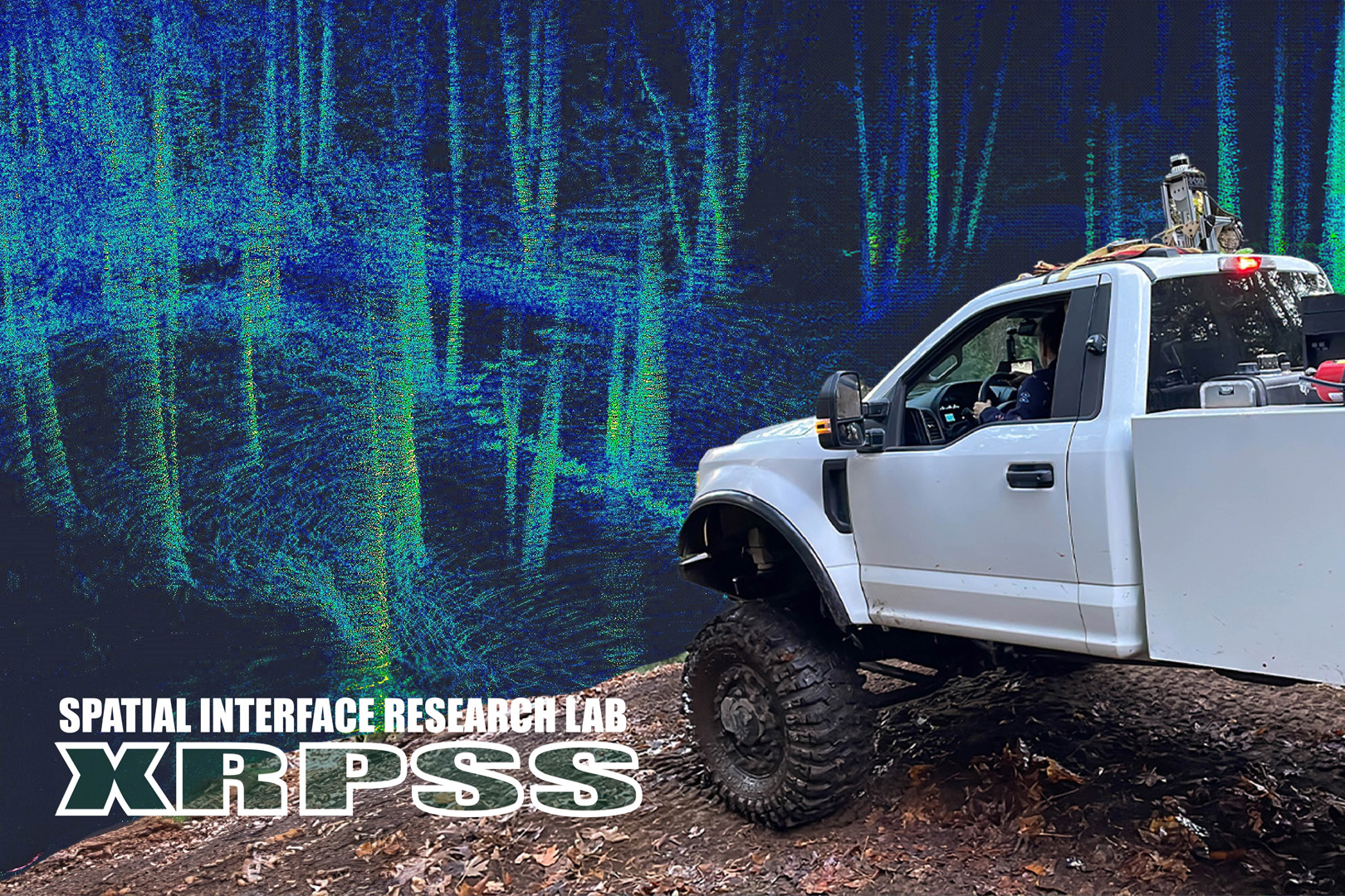
The Extended Reality Perceptual Support System (XRPSS) provides real-time 3D LiDAR sensor data to off-road vehicle drivers with interactive VR spatial query tools for the purposes of enhancing in-situ spatial awareness in complex natural environments. The system extends to ex-situ data exploration via motion driving simulators and VR.
References:
[1]
A ??LTEKIN, I LOCHHEAD, M MADDEN, ET AL. 2020. Extended Reality in Spatial Sciences: A Review of Research Challenges and Future Directions. ISPRS International Journal of Geo-Information 9, 7, 439.
[2]
JL GABBARD, GM FITCH, AND H KIM. 2014. Behind the Glass: Driver Challenges and Opportunities for AR Automotive Applications. Proceedings of the IEEE 102, 2, 124?136.
[3]
F-T GHIUR?U, MA BAYTAS, AND C WICKMAN. 2020. ARCAR: On-Road Driving in Mixed Reality by Volvo Cars. Poster Session, 3.
[4]
N HEDLEY AND I LOCHHEAD. 2020. TURNING 3D DATA SURVEYS OF INTERTIDAL ZONES INTO NEW MODES OF 3D VISUALIZATION, SIMULATION AND SPATIAL INTERFACE EXPERIENCES. ISPRS – International Archives of the Photogrammetry, Remote Sensing and Spatial Information Sciences XLIII-B4-2020, 791?794.
[5]
JANINA LATZA. 2022. Highly dynamic and completely real turns in a virtual world: BMW ///M Mixed Reality revolutionizes driving experience. .
[6]
K KIM, JV CARLIS, AND DF KEEFE. 2017. Comparison techniques utilized in spatial 3D and 4D data visualizations: A survey and future directions. Computers & Graphics 67, 138?147.
[7]
M LABB? AND F MICHAUD. 2019. RTAB-Map as an Open-Source Lidar and Visual SLAM Library for Large-Scale and Long-Term Online Operation. Journal of Field Robotics 36, 2, 416?446.
[8]
Y LIU, AL CLAIR, M DOUDE, AND VRF BURCH. 2018. Development of a Data Acquisition System for Autonomous Vehicle Systems. International Journal of Vehicle Structures and Systems 10, 4.
[9]
I LOCHHEAD AND N HEDLEY. 2021. Designing Virtual Spaces for Immersive Visual Analytics. KN – Journal of Cartography and Geographic Information 71, 4, 223?240.
[10]
N DE OLIVEIRA FARIA. 2020. Evaluating Automotive Augmented Reality Head-up Display Effects on Driver Performance and Distraction. 2020 IEEE Conference on Virtual Reality and 3D User Interfaces Abstracts and Workshops (VRW), 553?554.
[11]
M PIERZCHA?A, P GIGU?RE, AND R ASTRUP. 2018. Mapping forests using an unmanned ground vehicle with 3D LiDAR and graph-SLAM. Computers and Electronics in Agriculture 145, 217?225.
[12]
M QUIGLEY, K CONLEY, B GERKEY, ET AL. 2009. ROS: an open-source Robot Operating System. .
[13]
Y WANG, Q CHEN, Q ZHU, L LIU, C LI, AND D ZHENG. 2019. A Survey of Mobile Laser Scanning Applications and Key Techniques over Urban Areas. Remote Sensing 11, 13, 1540.
[14]
Unity. 2023. XR INTERACTION TOOLKIT. https://docs.unity3d.com/Packages/com.unity.xr.interaction.toolkit@3.0/manual/index.html.