
“Orometry-based terrain analysis and synthesis” by Argudo, Galin, Peytavie, Gain, Guérin, et al. …
Conference:
Type(s):
Title:
- Orometry-based terrain analysis and synthesis
Session/Category Title:
- Geometry with Style
Presenter(s)/Author(s):
Moderator(s):
Abstract:
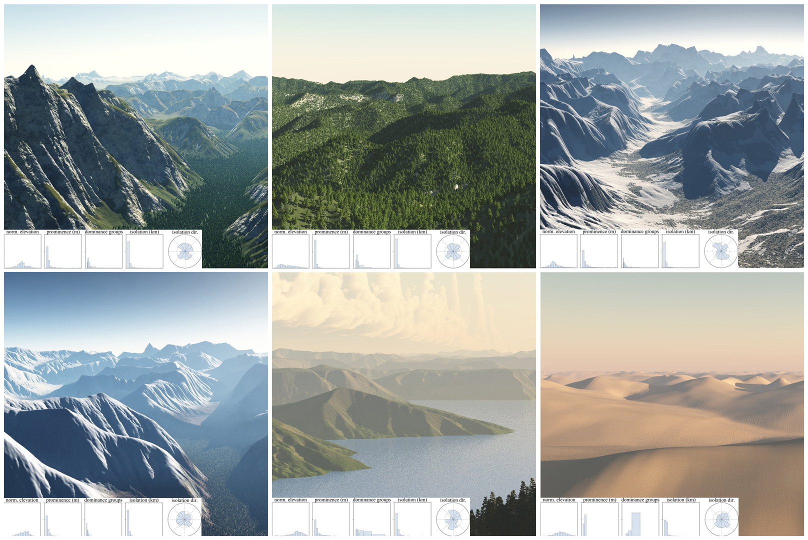
Mountainous digital terrains are an important element of many virtual environments and find application in games, film, simulation and training. Unfortunately, while existing synthesis methods produce locally plausible results they often fail to respect global structure. This is exacerbated by a dearth of automated metrics for assessing terrain properties at a macro level.We address these issues by building on techniques from orometry, a field that involves the measurement of mountains and other relief features. First, we construct a sparse metric computed on the peaks and saddles of a mountain range and show that, when used for classification, this is capable of robustly distinguishing between different mountain ranges. Second, we present a synthesis method that takes a coarse elevation map as input and builds a graph of peaks and saddles respecting a given orometric distribution. This is then expanded into a fully continuous elevation function by deriving a consistent river network and shaping the valley slopes. In terms of authoring, users provide various control maps and are also able to edit, reposition, insert and remove terrain features all while retaining the characteristics of a selected mountain range.The result is a terrain analysis and synthesis method that considers and incorporates orometric properties, and is, on the basis of our perceptual study, more visually plausible than existing terrain generation methods.
References:
1. Sawsan AlHalawani, Yong-Liang Yang, Peter Wonka, and Niloy J. Mitra. 2014. What Makes London Work Like London? Computer Graphics Forum 33, 5 (2014), 157–165.Google ScholarDigital Library
2. Oscar Argudo, Carlos Andujar, Antonio Chica, Eric Guérin, Julie Digne, Adrien Peytavie, and Eric Galin. 2017. Coherent multi-layer landscape synthesis. The Visual Computer 33, 6 (2017), 1005–1015.Google ScholarDigital Library
3. Farès Belhadj. 2007. Terrain modeling: a constrained fractal model. In Proceedings of the International Conference on Computer Graphics, Virtual Reality, Visualisation and Interaction in Africa. ACM, Grahamstown, South Africa, 197–204.Google ScholarDigital Library
4. Nicolas Bonneel, Michiel van de Panne, Sylvain Paris, and Wolfgang Heidrich. 2011. Displacement Interpolation Using Lagrangian Mass Transport. ACM Transactions on Graphics 30, 6 (Dec. 2011), 158:1–158:12.Google ScholarDigital Library
5. Lidija Čomić, Leila De Floriani, and Laura Papaleo. 2005. Morse-Smale Decompositions for Modeling Terrain Knowledge. In Spatial Information Theory, Anthony G. Cohn and David M. Mark (Eds.). Springer, Berlin, Heidelberg, 426–444.Google Scholar
6. Guillaume Cordonnier, Jean Braun, Marie-Paule Cani, Bedrich Benes, Eric Galin, Adrien Peytavie, and Eric Guérin. 2016. Large Scale Terrain Generation from Tectonic Uplift and Fluvial Erosion. Computer Graphics Forum 35, 2 (2016), 165–175.Google ScholarCross Ref
7. Guillaume Cordonnier, Eric Galin, James Gain, Bedrich Benes, Eric Guérin, Adrien Peytavie, and Marie-Paule Cani. 2017. Authoring Landscapes by Combining Ecosystem and Terrain Erosion Simulation. ACM Transactions on Graphics 36, 4 (2017), 134:1–134:12.Google ScholarDigital Library
8. Edward Earl and David Metzler. 2015. Cloud-Capped Towers: Capturing Terrain Characteristics Using Topographic Functionals. Quaestiones Geographicae 34, 4 (December 2015), 7–23.Google ScholarCross Ref
9. Anna Frühstück, Ibraheem Alhashim, and Peter Wonka. 2019. TileGAN: Synthesis of Large-Scale Non-Homogeneous Textures. ACM Transactions on Graphics (Proceedings of SIGGRAPH) 38, 4 (2019), 58:1–58:11.Google Scholar
10. Steve Fry. 1987. Defining and sizing-up mountains. Summit, Jan.-Feb. (1987), 16–21,32.Google Scholar
11. James Gain, Bruce Merry, and Patrick Marais. 2015. Parallel, Realistic and Controllable Terrain Synthesis. Computer Graphics Forum 34, 2 (2015), 105–116.Google ScholarDigital Library
12. James E. Gain, Patrick Marais, and Wolfgang Strasser. 2009. Terrain sketching. In Proceedings of the Symposium on Interactive 3D Graphics and Games. ACM, Boston, USA, 31–38.Google ScholarDigital Library
13. Eric Galin, Eric Guérin, Adrien Peytavie, Guillaume Cordonnier, Marie-Paule Cani, Bedrich Benes, and James Gain. 2019. A Review of Digital Terrain Modeling. Computer Graphics Forum (proceedings of Eurographics 2019 STAR) 38, 2 (2019), 553–577.Google Scholar
14. Jean-David Génevaux, Éric Galin, Eric Guérin, Adrien Peytavie, and Bedrich Benes. 2013. Terrain Generation Using Procedural Models Based on Hydrology. ACM Transactions on Graphics. 32, 4 (2013), 143:1–143:13.Google ScholarDigital Library
15. Jean-David Génevaux, Éric Galin, Adrien Peytavie, Éric Guérin, Cyril Briquet, François Grosbellet, and Bedrich Benes. 2015. Terrain Modeling from Feature Primitives. Computer Graphics Forum 34, 6 (2015), 198–210.Google ScholarCross Ref
16. Eric Guérin, Julie Digne, Eric Galin, and Adrien Peytavie. 2016. Sparse representation of terrains for procedural modeling. Computer Graphics Forum (Proceedings of Eurographics) 35, 2 (2016), 177–187.Google ScholarCross Ref
17. Éric Guérin, Julie Digne, Éric Galin, Adrien Peytavie, Christian Wolf, Bedrich Benes, and Benoît Martinez. 2017. Interactive Example-based Terrain Authoring with Conditional Generative Adversarial Networks. ACM Transactions on Graphics 36, 6 (2017), 228:1–228:13.Google ScholarDigital Library
18. Adam Helman. 2005. The Finest Peaks. Prominence and Other Mountain Measures. Trafford Publishing.Google Scholar
19. Houssam Hnaidi, Éric Guérin, Samir Akkouche, Adrien Peytavie, and Éric Galin. 2010. Feature based terrain generation using diffusion equation. Computer Graphics Forum 29, 7 (2010), 2179–2186.Google ScholarCross Ref
20. Eberhard Jurgalski. 2016. Das erweiterte Prominenzkonzept. Ein mathematisches Einteilungssystem für alle Berge und Gebirge, weltweit anwendbar vom Hochgebirge bis zu Heimathügeln. Mitteilungen der Fränkischen Geographischen Gesellschaft 61/62 (2016), 105–110.Google Scholar
21. Alex D. Kelley, Michael C. Malin, and Gregory M. Nielson. 1988. Terrain simulation using a model of stream erosion. Computer Graphics 22, 4 (1988), 263–268.Google ScholarDigital Library
22. Andrew Kirmse and Jonathan de Ferranti. 2017. Calculating the prominence and isolation of every mountain in the world. Progress in Physical Geography: Earth and Environment 41, 6 (2017), 788–802.Google ScholarCross Ref
23. Benoit B. Mandelbrot. 1982. The Fractal Geometry of Nature. W. H. Freeman & Co Ltd.Google Scholar
24. David M. Mark. 1981. Topology of ridge patterns: Possible physical interpretation of the “minimum spanning tree” postulate. Geology 9, 8 (08 1981), 370–372.Google Scholar
25. Christine May, Josh Roering, L Eaton, and Burnett Kelly. 2013. Controls on valley width in mountainous landscapes: The role of landsliding and implications for salmonid habitat. Geology 41 (03 2013), 503–506.Google Scholar
26. Forest Kenton Musgrave, Craig E. Kolb, and Robert S. Mace. 1989. The synthesis and rendering of eroded fractal terrains. Computer Graphics 23, 3 (1989), 41–50.Google ScholarDigital Library
27. Ian Parberry. 2014. Designer Worlds: Procedural Generation of Infinite Terrain from Real-World Elevation Data. Journal of Computer Graphics Techniques 3, 1 (2014), 74–85.Google Scholar
28. Ian Parberry. 2015. Modeling Real-World Terrain with Exponentially Distributed Noise. Journal of Computer Graphics Techniques 4, 2 (2015), 1–9.Google Scholar
29. Przemyslaw Prusinkiewicz and Marc Hammel. 1993. A fractal model of mountains with rivers. In Proceedings of Graphics Interface. Canadian Information Processing Society, Toronto, Canada, 174–180.Google Scholar
30. Christian Werner. 1988. Formal Analysis of Ridge and Channel Patterns in Maturely Eroded Terrain. Annals of the Association of American Geographers 78, 2 (1988), 253–270.Google ScholarCross Ref
31. Howard Zhou, Jie Sun, Greg Turk, and James M. Rehg. 2007. Terrain Synthesis from Digital Elevation Models. Transactions on Visualization and Computer Graphics 13, 4 (2007), 834–848.Google ScholarDigital Library
32. Yang Zhou, Zhen Zhu, Xiang Bai, Dani Lischinski, Daniel Cohen-Or, and Hui Huang. 2018. Non-stationary Texture Synthesis by Adversarial Expansion. ACM Transactions on Graphics (Proceedings of SIGGRAPH) 37, 4 (2018).Google Scholar