
“City-scale traffic animation using statistical learning and metamodel-based optimization” by Li, Wolinski and Lin
Conference:
Type(s):
Title:
- City-scale traffic animation using statistical learning and metamodel-based optimization
Session/Category Title:
- Fire, Flow and Flight
Presenter(s)/Author(s):
Abstract:
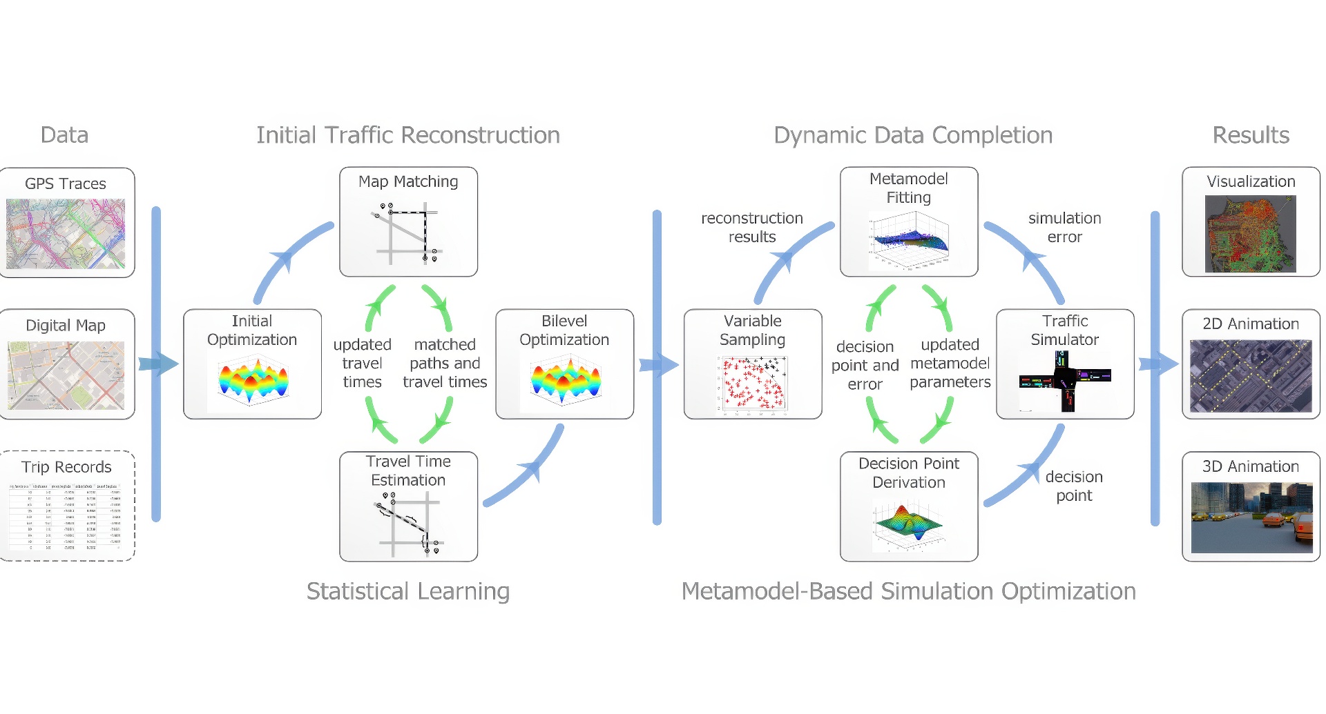
Rapid urbanization and increasing traffic have caused severe social, economic, and environmental problems in metropolitan areas worldwide. Traffic reconstruction and visualization using existing traffic data can provide novel tools for vehicle navigation and routing, congestion analysis, and traffic management. While traditional data collection methods are becoming increasingly common (e.g. using in-road sensors), GPS devices are also becoming ubiquitous. In this paper, we address the problem of traffic reconstruction, visualization, and animation using mobile vehicle data (i.e. GPS traces). We first conduct city-scale traffic reconstruction using statistical learning on mobile vehicle data for traffic animation and visualization, and then dynamically complete missing data using metamodel-based simulation optimization in areas of insufficient data coverage. We evaluate our approach quantitatively and qualitatively, and demonstrate our results with 2D visualization of citywide traffic, as well as 2D and 3D animation of reconstructed traffic in virtual environments.
References:
1. Natalia Andrienko and Gennady Andrienko. 2006. Exploratory analysis of spatial and temporal data: a systematic approach.
2. Christopher G. Atkeson, Andrew W. Moore, and Stefan Schaal. 1997. Locally Weighted Learning. Artif. Intell. Rev. 11, 1–5 (1997), 11–73. Salvador Bayarri, Marcos Fernandez, and Mariano Perez. 1996. Virtual Reality for Driving Simulation. Commun. ACM 39, 5 (1996), 72–76.
3. Sharminda Bera and K. V. Krishna Rao. 2011. Estimation of origin-destination matrix from traffic counts: the state of the art. European Transport\Trasporti Europei n. (2011), 3–23.
4. Huikun Bi, Tianlu Mao, Zhaoqi Wang, and Zhigang Deng. 2016. A data-driven model for lane-changing in traffic simulation. In Proceedings of the ACM SIGGRAPH/Eurographics Symposium on Computer Animation. 149–158.
5. Ennio Cascetta and Sang Nguyen. 1988. A unified framework for estimating or updating origin/destination matrices from traffic counts. Transportation Research Part B: Methodological 22, 6 (1988), 437–455. Cross Ref
6. Pablo Samuel Castro, Daqing Zhang, and Shijian Li. 2012. Urban traffic modelling and prediction using large scale taxi GPS traces. In International Conference on Pervasive Computing. 57–72.
7. Qianwen Chao, Zhigang Deng, Jiaping Ren, Qianqian Ye, and Xiaogang Jin. 2017. Realistic Data-Driven Traffic Flow Animation Using Texture Synthesis. IEEE Transactions on Visualization and Computer Graphics (2017).
8. Qianwen Chao, Jingjing Shen, and Xiaogang Jin. 2013. Video-based personalized traffic learning. Graphical Models 75, 6 (2013), 305–317.
9. Panayiotis Charalambous and Yiorgos Chrysanthou. 2014. The PAG Crowd: A Graph Based Approach for Efficient Data-Driven Crowd Simulation. Computer Graphics Forum 33, 8 (2014), 95–108.
10. Andrew Conn, Katya Scheinberg, and Luis N. Vicente. 2009. Introduction to derivative free optimization.
11. Nivan Ferreira, Jorge Poco, Huy T Vo, Juliana Freire, and Cláudio T Silva. 2013. Visual exploration of big spatio-temporal urban data: A study of new york city taxi trips. IEEE Transactions on Visualization and Computer Graphics 19, 12 (2013), 2149–2158.
12. Ignacio Garcia-Dorado, Daniel G. Aliaga, Saiprasanth Bhalachandran, Paul Schmid, and Dev Niyogi. 2017. Fast Weather Simulation for Inverse Procedural Design of 3D Urban Models. ACM Trans. Graph. 36, 2 (2017), 21:1–21:19.
13. I. Garcia-Dorado, D. G. Aliaga, and S. V. Ukkusuri. 2014. Designing large-scale interactive traffic animations for urban modeling. Computer Graphics Forum 33, 2 (2014), 411–420.
14. E. Hato, M. Taniguchi, Y. Sugie, M. Kuwahara, and H. Morita. 1999. Incorporating an information acquisition process into a route choice model with multiple information sources. Transportation Research Part C: Emerging Technologies 7, 2 (1999), 109–129. Cross Ref
15. Bruce Hellinga, Pedram Izadpanah, Hiroyuki Takada, and Liping Fu. 2008. Decomposing travel times measured by probe-based traffic monitoring systems to individual road segments. Transportation Research Part C: Emerging Technologies 16, 6 (2008), 768–782. Cross Ref
16. Juan C. Herrera, Daniel B. Work, Ryan Herring, Xuegang (Jeff) Ban, Quinn Jacobson, and Alexandre M. Bayen. 2010. Evaluation of traffic data obtained via GPS-enabled mobile phones: The Mobile Century field experiment. Transportation Research Part C: Emerging Technologies 18, 4 (2010), 568–583. Cross Ref
17. Ryan Herring, Aude Hofleitner, Pieter Abbeel, and Alexandre Bayen. 2010. Estimating arterial traffic conditions using sparse probe data. In Intelligent Transportation Systems (ITSC), 13th International IEEE Conference on. 929–936.
18. Aude Hofleitner, Ryan Herring, and Alexandre Bayen. 2012. Probability distributions of travel times on arterial networks: a traffic flow and horizontal queuing theory approach. In 91st Transportation Research Board Annual Meeting.
19. Timothy Hunter. 2014. Large-Scale, Low-Latency State Estimation Of Cyberphysical Systems With An Application To Traffic Estimation. Ph.D. Thesis (2014).
20. Timothy Hunter, Pieter Abbeel, and Alexandre Bayen. 2014. The path inference filter: model-based low-latency map matching of probe vehicle data. Intelligent Transportation Systems, IEEE Transactions on 15, 2 (2014), 507–529. Cross Ref
21. Eunjung Ju, Myung Geol Choi, Minji Park, Jehee Lee, Kang Hoon Lee, and Shigeo Takahashi. 2010. Morphable Crowds. ACM Trans. Graph. 29, 6 (2010), 140:1–140:10.
22. Pushkin Kachroo and Shankar Sastry. 2016. Travel time dynamics for intelligent transportation systems: theory and applications. IEEE Transactions on Intelligent Transportation Systems 17, 2 (2016), 385–394. Cross Ref
23. Qing-Jie Kong, Qiankun Zhao, Chao Wei, and Yuncai Liu. 2013. Efficient traffic state estimation for large-scale urban road networks. IEEE Transactions on Intelligent Transportation Systems 14, 1 (2013), 398–407.
24. Daniel Krajzewicz, Jakob Erdmann, Michael Behrisch, and Laura Bieker. 2012. Recent Development and Applications of SUMO – Simulation of Urban MObility. International Journal On Advances in Systems and Measurements 5, 3–4 (2012), 128–138.
25. Jon Kuhl, Douglas Evans, Yiannis Papelis, Richard Romano, and Ginger Watson. 1995. The Iowa Driving Simulator: An Immersive Research Environment. Computer 28, 7 (1995), 35–41.
26. Kang Hoon Lee, Myung Geol Choi, Qyoun Hong, and Jehee Lee. 2007. Group behavior from video: a data-driven approach to crowd simulation. In Proceedings of the 2007 ACM SIGGRAPH/Eurographics symposium on Computer animation. Eurographics Association, 109–118.
27. Alon Lerner, Yiorgos Chrysanthou, and Dani Lischinski. 2007. Crowds by Example. Computer Graphics Forum 26, 3 (2007), 655–664. Cross Ref
28. Li Li, Xiqun Chen, and Lei Zhang. 2014. Multimodel ensemble for freeway traffic state estimations. IEEE Transactions on Intelligent Transportation Systems 15, 3 (2014), 1323–1336. Cross Ref
29. Minglei Li, Peter Wonka, and Liangliang Nan. 2016. Manhattan-World Urban Reconstruction from Point Clouds. In European Conference on Computer Vision. 54–69. Cross Ref
30. Weizi Li, Dong Nie, David Wilkie, and Ming C. Lin. 2017. Citywide Estimation of Traffic Dynamics Via Sparse GPS Traces. IEEE Intelligent Transportation Systems Magazine 9, 3 (2017), 100–113. Cross Ref
31. Wen-Chieh Lin, Sai-Keung Wong, Cheng-Hsing Li, and Richard Tseng. 2016. Generating Believable Mixed-Traffic Animation. IEEE Transactions on Intelligent Transportation Systems 17, 11 (2016), 3171–3183.
32. Xuequan Lu, Zonghui Wang, Mingliang Xu, Wenzhi Chen, and Zhigang Deng. 2014. A personality model for animating heterogeneous traffic behaviors. Computer animation and virtual worlds 25, 3–4 (2014), 361–371.
33. Tianlu Mao, Hua Wang, Zhigang Deng, and Zhaoqi Wang. 2015. An efficient lane model for complex traffic simulation. Computer Animation and Virtual Worlds 26, 3–4 (2015), 397–403.
34. Microsoft. 2009. GeoLife Project. www.microsoft.com/en-us/research/project/geolife-building-social-networks-using-human-location-history/. (2009).
35. Microsoft. 2010. T-Drive Project. www.microsoft.com/en-us/research/project/t-drive-driving-directions-based-on-taxi-traces/. (2010).
36. MIT. 2011. MITIntelligent Transportation Systems. its.mit.edu/. (2011).
37. P. Musialski, P. Wonka, D. G. Aliaga, M. Wimmer, L. van Gool, and W. Purgathofer. 2013. A Survey of Urban Reconstruction. Computer Graphics Forum 32, 6 (2013), 146–177.
38. Carolina Osorio. 2010. Mitigating network congestion: analytical models, optimization methods and their applications. Ph.D. Dissertation.
39. Carolina Osorio and Michel Bierlaire. 2013. A simulation-based optimization framework for urban transportation problems. Operations Research 61, 6 (2013), 1333–1345.
40. Carolina Osorio, Gunnar Flötteröd, and Chao Zhang. 2015. A metamodel simulation-based optimization approach for the efficient calibration of stochastic traffic simulators. Transportation Research Procedia 6 (2015), 213–223. Cross Ref
41. Mikko Perttunen, Vassilis Kostakos, Jukka Riekki, and Timo Ojala. 2015. Urban traffic analysis through multi-modal sensing. Personal and Ubiquitous Computing 19, 3–4 (2015), 709–721.
42. Michal Piorkowski, Natasa Sarafijanovic-Djukic, and Matthias Grossglauser. 2009. CRAWDAD dataset epfl/mobility (v. 2009-02-24). Downloaded from http://crawdad.org/epfl/mobility/20090224. (2009).
43. Mohammed Quddus and Simon Washington. 2015. Shortest path and vehicle trajectory aided map-matching for low frequency GPS data. Transportation Research Part C: Emerging Technologies 55 (2015), 328–339. Cross Ref
44. Mahmood Rahmani, Erik Jenelius, and Haris Koutsopoulos. 2015. Non-parametric estimation of route travel time distributions from low-frequency floating car data. Transportation Research Part C: Emerging Technologies 58 (2015), 343–362. Cross Ref
45. David Schrank, Bill Eisele, Tim Lomax, and Jim Bak. 2015. 2015 Urban Mobility Scorecard. Texas A&M Transportation Institute and INRIX (2015).
46. Jason Sewall, Jur Van Den Berg, Ming Lin, and Dinesh Manocha. 2011a. Virtualized traffic: Reconstructing traffic flows from discrete spatiotemporal data. IEEE Transactions on Visualization and Computer Graphics 17, 1 (2011), 26–37.
47. Jason Sewall, David Wilkie, and Ming C. Lin. 2011b. Interactive Hybrid Simulation of Large-scale Traffic. ACM Trans. Graph. 30, 6 (2011), 135:1–135:12.
48. Jason Sewall, David Wilkie, Paul. Merrell, and Ming C. Lin. 2010. Continuum Traffic Simulation. Computer Graphics Forum 29, 2 (2010), 439–448. Cross Ref
49. Yosef Sheffi. 1985. Urban Transportation Network. Pretince Hall.
50. Jingjing Shen and Xiaogang Jin. 2012. Detailed traffic animation for urban road networks. Graphical Models 74, 5 (2012), 265–282.
51. TAC. 2017. TAC’s virtual reality driving school. www.smh.com.au/victoria/. (2017).
52. Jinjin Tang, Ying Song, and Xuesong Miller, Harveyand Zhou. 2016. Estimating the most likely space-time paths, dwell times and path uncertainties from vehicle trajectory data: A time geographic method. Transportation Research Part C: Emerging Technologies 66 (2016), 176–194. Cross Ref
53. Gwenola Thomas and Stéphane Donikian. 2000. Modelling virtual cities dedicated to behavioural animation. Computer Graphics Forum 19, 3 (2000), 71–80. Cross Ref
54. Robert Tibshirani, Michael Saunders, Saharon Rosset, Ji Zhu, and Keith Knight. 2005. Sparsity and smoothness via the fused lasso. Journal of the Royal Statistical Society: Series B 67, 1 (2005), 91–108. Cross Ref
55. Uber. 2017. Uber Movement. movement.uber.com/. (2017).
56. Jur van den Berg, Jason Sewall, Ming Lin, and Dinesh Manocha. 2009. Virtualized traffic: Reconstructing traffic flows from discrete spatio-temporal data. In Virtual Reality Conference, IEEE. 183–190.
57. Hongling Wang, Joseph K Kearney, James Cremer, and Peter Willemsen. 2005. Steering behaviors for autonomous vehicles in virtual environments. In Virtual Reality Conference, IEEE. 155–162.
58. Yuqi Wang, Jiannong Cao, Wengen Li, and Tao Gu. 2016. Mining Traffic Congestion Correlation between Road Segments on GPS Trajectories. In 2016 IEEE International Conference on Smart Computing (SMARTCOMP). 1–8. Cross Ref
59. Zuchao Wang, Tangzhi Ye, MinLu, Xiaoru Yuan, Huamin Qu, Jacky Yuan, and Qianliang Wu. 2014. Visual exploration of sparse traffic trajectory data. IEEE Transactions on Visualization and Computer Graphics 20, 12 (2014), 1813–1822. Cross Ref
60. John Wardrop. 1952. Some theoretical aspects of road traffic research. Proceedings of the Institution of Civil Engineers 1, 3 (1952), 325–362. Cross Ref
61. David Wilkie, Cenk Baykal, and Ming C Lin. 2014. Participatory route planning. In Proceedings of the 22nd ACM SIGSPATIAL International Conference on Advances in Geographic Information Systems. ACM, 213–222.
62. David Wilkie, Jason Sewall, Weizi Li, and Ming C. Lin. 2015. Virtualized Traffic at Metropolitan Scales. Frontiers in Robotics and AI 2 (2015), 11. Cross Ref
63. David Wilkie, Jason Sewall, and Ming C Lin. 2012. Transforming GIS data into functional road models for large-scale traffic simulation. IEEE transactions on visualization and computer graphics 18, 6 (2012), 890–901.
64. David Wilkie, Jason Sewall, and Ming C. Lin. 2013. Flow Reconstruction for Data-driven Traffic Animation. ACM Trans. Graph. 32, 4 (2013), 89:1–89:10.
65. David Wilkie, Jur P van den Berg, Ming C Lin, and Dinesh Manocha. 2011. Self-Aware Traffic Route Planning. In AAAI, Vol. 11. 1521–1527.
66. P. Willemsen, J. K. Kearney, and H. Wang. 2006. Ribbon networks for modeling navigable paths of autonomous agents in virtual environments. IEEE Transactions on Visualization and Computer Graphics 12, 3 (2006), 331–342.
67. Daniel Work, Sébastien Blandin, Olli-Pekka Tossavainen, Benedetto Piccoli, and Alexandre Bayen. 2010. A traffic model for velocity data assimilation. Applied Mathematics Research Express 2010, 1 (2010), 1–35.
68. Cathy Wu, Jérôme Thai, Steve Yadlowsky, Alexei Pozdnoukhov, and Alexandre Bayen. 2015. Cellpath: Fusion of Cellular and Traffic Sensor Data for Route Flow Estimation via Convex Optimization. Transportation Research Procedia 7 (2015), 212 — 232. Cross Ref
69. Hai Yang, Tsuna Sasaki, Yasunori Iida, and Yasuo Asakura. 1992. Estimation of origin-destination matrices from link traffic counts on congested networks. Transportation Research Part B: Methodological 26, 6 (1992), 417–434. Cross Ref
70. Xianfeng Yang, Yang Lu, and Wei Hao. 2017. Origin-Destination Estimation Using Probe Vehicle Trajectory and Link Counts. Journal of Advanced Transportation (2017).
71. Jing Yuan, Yu Zheng, Chengyang Zhang, Xing Xie, and Guang-Zhong Sun. 2010. An interactive-voting based map matching algorithm. In Proceedings of the 11th International Conference on Mobile Data Management. 43–52.
72. Jia-Dong Zhang, Jin Xu, and Stephen Shaoyi Liao. 2013. Aggregating and sampling methods for processing GPS data streams for traffic state estimation. IEEE Transactions on Intelligent Transportation Systems 14, 4 (2013), 1629–1641.
73. Yu Zheng, Yanchi Liu, Jing Yuan, and Xing Xie. 2011. Urban computing with taxicabs. In Proceedings of the 13th international conference on Ubiquitous computing. ACM, 89–98.